Silitz Bay Park
Just to the south of Lincoln City is Silitz Bay Park. The car park has a great view over the bay, and the small chain of islands leading away from the coast.
Like most of even the tiniest parks that lay just off Highway 101, it has useful information signs and a restroom. These restrooms vary between brick or wooden huts with a full set of toilets and plumbing, to the more basic long-drop port-a-potty design. No matter the style, they’re always clean and well stocked.
Seal Rock
Travelling south from Newport, one of the largest rock formations noticeable near the shore is called Seal Rocks. The Seal Rocks parallel the shore for about 2.5 miles, ending with the largest rock, called…yep…Seal Rock.
The name comes from the pidgin trade language of the Pacific Northwest, called Chinook Jargon. The rocks are resting place for hundreds of seals, so they called it Seal Illahe, which unsurprisingly means Seal Rock. Despite all this, we couldn’t see or hear any seals…
Devil’s Churn
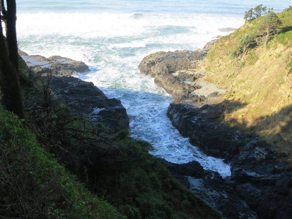
This small inlet near Cape Perpetua formed over thousands of years, to become a deep cave into the basalt cliff. Eventually the roof collapsed, creating a funnel effect that channels waves and throws spray several hundred feet into the air.
North Bend Bridge
As Highway 101 passes alongside the Oregon Dunes National Park, the landscape on the coastal side changes from lush green trees to sandy dunes.
Roughly in the middle is the town of North Bend, home to the Coquille tribe. It’s easy to recognise when you’re in the area as there’s a huge estuary, spanned by the Conde B. McCullough Memorial Bridge, formerly the Coos Bay Bridge.
When completed in 1936 it was the longest and most expensive of the eleven major Highway 101 bridges in Oregon.
Horsfall Beach
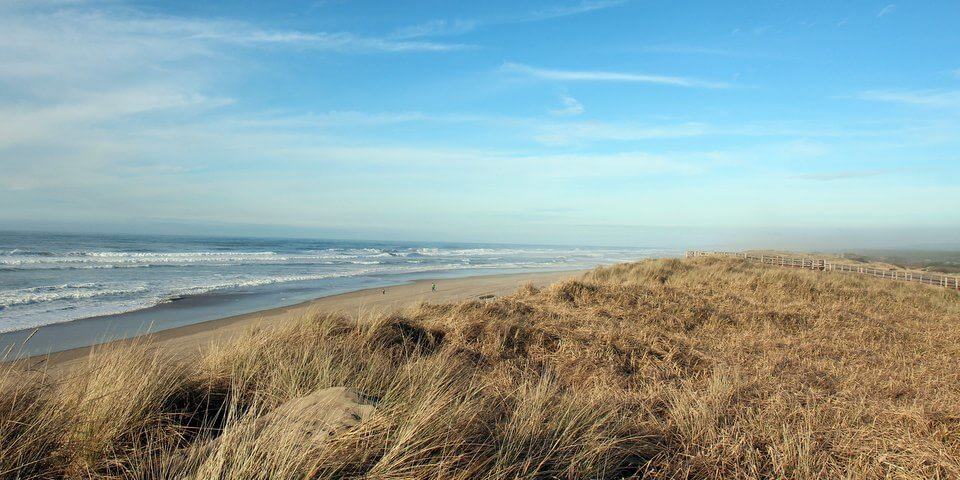
One of the more southern beaches in the 47-mile long Oregon Dunes National Park, Horsfall is exactly how I imagined an American wilderness beach. A wooden walkway leads visitors over the grassy tufts to a clean white beach, strewn with driftwood and even a rotting ship.
Judging by the contents of the car park, the beach is also popular with quad bikers and horse riders. Like most remote state parks there is no fee for using the park, but there is a $5 payment for parking.
There’s a secure post box with little envelopes. Put the money inside an envelope, tear off the label to display in the car window and post the remaining envelope in the post box. Walking through the car park we seemed to be in the minority that bothered to pay.
Umpqua River Lighthouse
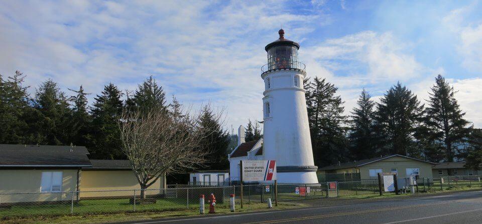
The first lighthouse at the entrance to Winchester Bay was built in 1855, but had a major design flaw. ..it was below the high water mark. This annual flooding weakened the foundations enough that it collapsed within 10 years.
The current lighthouse was built in 1892, this time 30m above the river. The new spot is opposite a large whale watching platform.
Sunset Bay State Park
A huge crescent shaped bay, with a flat sandy beach flanked by pine trees. One of the many moments in Oregon I wished we were driving an RV and could have stopped and waited for the sunset.








I love driving along 101! As for the parking fee, for those that did not have the torn off label, they may have had the year long state park pass. You may not have known, but if you buy that pass it covers most parking and entrance fees into state parks. We had one every year we lived in Oregon and it saved so much money, especially along 101.
Though, I am sure there were some that dodged paying; there is a stiff fine for not, which is far greater than the actual fee. Risky.
Those annual passes would be a great deal – do they have them in most states, or even a national version?
I believe there is a national pass, but it will only cover parks under the federal administration. I am not sure about most states, I only know Oregon for sure because I lived there. My husband and I spent so much time outside–hiking, canoeing, road traveling — that it ultimately saved us a lot of money on parking and entrance fees. Plus, we did not mind paying to help support the awesome park services our state offers.
I’ll be going to the USA in a couple of months and I’m not sure why but Oregon is one of the states I’m most excited about! It looks so green and open.
It’s somewhere I could happily live. We stuck to the coastal road, but I’d love to go back and visit the Crater Lakes area in warmer weather.
It is a spectacular place! I grew up in KY but claim Oregon as home. We loved living there and continue to love it, though job wise it is wretched and that is the reason we moved to China to teach.
When you are there, make sure to check out these sites: aroundthesunblog.com, http://blogging.portlandonthecheap.com/ and http://www.portlandoregon.gov/parks/index.cfm?. The first two highlight FREE things in and around Portland, while the third is for the parks department. During the summer they have free concerts and movies in the park. Oregon really has so many free things, it is crazy. One year, my husband and I declared it the year of the festivals and we attended a different festival (or even two) every week of the year. It was so much fun and the majority of them were free.
I do have a blog (not self toting here) but I did write about the fun we had in our beloved state: http://www.littlebylittleonetravelsfar.blogspot.com
Pingback: @AidanAdisynsMOm
Pingback: @HandcarryOnly
Pingback: @travels4couples
Pingback: Steve Juba (@solotravelclubs)
I’ve always wanted to go a Great American Road Trip. Being from the Midwest, I know all about that area and only just went to NYC and Boston last year! Oregon has long been a place I’d love to see!
Pingback: Cat Gaa (@sunshinesiestas)
Pingback: Dr. Jessica Voigts (@WanderingEds)
now that is SOOO beautiful!! Road Trip Time!
We love road trips and the Oregon Coast is definitely on our list. . .thanks for providing some highlights 🙂
Pingback: Changes in Longitude (@Changes_Long)
What a stunning slice of coastline Stephen. I can’t wait to explore the Pacific Northwest. Isn’t the US just the best country for roadtripping?
I’ve always wanted to do a West Coast roadtrip – Oregon looks stunning!
All the way down from Oregon to California has an amazing coastline
The Oregon coast is beautiful. Took a bucket list trip & fell in love with depoe bay. We did 1225 miles and could do it all over again with a totally new experience. so many beautiful things all around .